“No man is an island, entire of itself,” said the English poet John Donne in 1624. Apart from the obvious literary truth, we understand from his words that human beings do not thrive without company.
Islands, by themselves, may not amount too much. But when you group them together, they can combine their qualities to outdo any mainland. All islanders know this, and now it‘s time for you to experience it as well.
Donne‘s words still ring true for Icelanders today. In small nations, all the islands need each other. And even though we usually think of Iceland itself as one island, it‘s actually surrounded by countless smaller islands. Islands that play an important role in the history of the country, in one way or another.
Just as you might want to get to know the human „islands“, one by one, during your travel through Iceland, why not visit some of the more interesting geographical islands as well.
Why not go properly island-hopping?
… ambiguity intended.
10. Grótta
Where is it? In the North-west corner of the capital area, Grótta belongs to one of Reykjavik‘s neighbouring towns, Seltjarnarnes.

Why is it interesting? Having once been a prosperous farm setting, at least until the year 1799, Grótta is now a tidal island that houses a light house and a learning center for school children. It is also a popular recreational area, as you can walk to the island on dry feet during low tide. On old maps, Grótta is a part of the mainland and not an island, and a small coastal barrier extending from it to the south, actually created the pond the peninsula is named after (Seltjarnarnes = seal-pond-peninsula). Natural erosion and disaster flooding have long since destroyed the barrier and who knows what might happen to Grótta in the future?
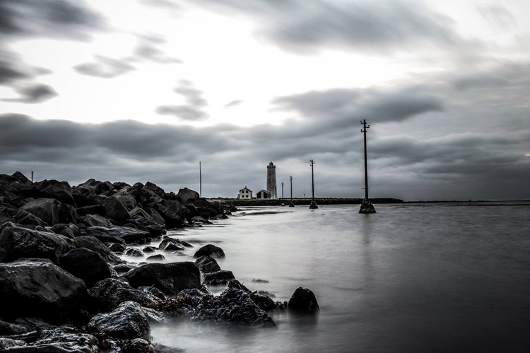
How to get there? Once you‘ve taken a bus to Seltjarnarnes, Grótta is within easy walking distance. Just be sure to mind the tide, as you can be stranded on the island for hours if the walkway to land gets flooded. Due to birds nesting, all traffic to Grótta is restricted from May 1st until July 15th each year.
9. Papey
Where is it? South-east of Djúpivogur in the East of Iceland. Papey is about 2 square kilometers in size and rises up to 58 meters above sea level.
Why is it interesting? Papey is mentioned in the book of settlements as one of two places inhabited by Irish (or possibly Scottish) monks, papar, when the first nordic settlers came to Iceland in 874. Even though modern archaeological surveys have not found any evidence of the monks, the island was inhabited from the settlement until 1966. The Irish (westmen) did play a significant role in the settlement of Iceland, but their stories very seldom have a happy ending. In the book of settlements it says that women in Ingólfur Arnarson‘s (the first settler) company spotted the smoke in Papey that led to the discovery of the monks. One can only imagine what happened next. Today, Papey is not lived in, but there is a light house there, as well as a house and a church. The island is also home to a large number of puffins and at least 124 different kinds of higher plants, and was the backdrop for one of the biggest drug-bust the Icelandic police has ever made.
How to get there? During summer, there are daily boat trips to Papey from Djúpivogur. They focus on bird life, seals and history but you can also book sea angling tours. Camping is permitted in Papey.
8. Hrísey
Where is it? In the middle of Eyjafjörður, the fjord Akureyri sits by, in North Iceland.
Why is it interesting? Apart from being the second largest island around Iceland (8 square km), Hrísey is mainly known for various links to animals. As dogs and cats are not permitted on the island, over 40 species of birds have a sanctuary there. And yet, the island houses the isolation center all animals must spend a period of time in, when they are imported into the country. Including cats and dogs. There is also a shark museum on the island and even a swimming pool, campsite, restaurant and a sports center. The most famous dish in Hrísey is without a doubt the locally bred Galloway beef. Islanders used to rely on fishing, but also have a very active social live. Today the population of the island is about 200.
How to get there? Ferry from Árskógssandur takes about 15 minutes and runs several times during the day in the summer.
7. Drangey
Where is it? In the middle of Skagafjörður, close to towns like Hofsós and Sauðárkrókur.
Why is it interesting? Where to start? Grettir Ásmundarson, the hero of Grettis saga, became an outlaw after wrestling with a ghost, being cursed and accidentally killing a lot of men by burning down a house. As one did.
He then moved to Drangey along with one of his brother and a slave. The locals didn‘t like the idea of an outlaw in the island so they got a man to try to kill him. As it‘s difficult to get to the island, specially unnoticed, he did not succeed and Grettir stayed there for a few years. At one time, their fire went out and Grettir swam to the mainland and then back with a flaming torch. Finally the contracted killer got his mother to put a spell, via driftwood, on Grettir who later swung an axe to his own leg, got infected and was killed along with his brother when lying terminally ill in bed. Due to the unfair way Grettir was killed, his killer did not collect any money and had to leave the country. Another of Grettir‘s brothers chased the killer to Norway and got revenge.
The island itself is also quite interesting. It is the remnant of a 700 000 year old volcano and is home to a lot of sea birds, including puffins, falcons and guillemots. In the past, as many as 200 000 birds were caught in the island, annually, as food for local people.
There is a folk-story about the origin of the island. It tells of two night prowling giants or trolls, who were pulling a cow over the fjord in order for her to meet with a bull. As so often happens in these stories, the sun came up and they turned into stone. The troll-woman is still standing to the south of the main island who is, reportedly, the cow. The troll-man used to stand north of the cow but has disappeared into the sea.
How to get there? Drangey is a pleasure to watch from land, but boat trips can be done from Reykir (where Grettir got the fire he swam with to Drangey). You can choose from getting on top of the 180 m high island, or sail around it.
6. Viðey
Where is it? A stones throw from Reykjavik, the capital. Like, really really close.
Why is it interesting? Having been inhabited as early as 10th century, Viðey was an active volcano about 2 million years ago. About 9 or 10 thousand years ago, the island started to rise from the ocean. In the 1225 a monastery was founded in Viðey, that lasted to 1539 when the Danish king‘s men raided it and claimed all possessions as the king‘s.
The first stonehouse built in Iceland is in Viðey, built in 1755 by sherif Skúli Magnússon. It is still standing but is used today as a restaurant. The island later housed a print shop, the country‘s first harbour for ocean-crossing ships and a village of 100 people, although nobody lives there today.
In 2007, Yoko Ono and Sean Lennon came to Viðey to celebrate the installment of the „Tower of light“, envisioned and built by Ono in memory of John Lennon. The tower is a beam of light, with the words „imagine peace“ written in 24 languages on the casing of the light. It stayes lid from October 9th (Lennon‘s birthday) until December 8th (Lennon‘s date of death) each year.
How to get there? If you don‘t feel like swimming 720 meters (Grettir wouldn‘t have minded), you can take a ferry from three different locations in Reykjavik, including Harpa concert hall. The frequency of departures depends on location, but if you want to go to Viðey – you will be able to find a time that‘s good for you.
5. Kolbeinsey
Where is it? In the middle of effing nowhere. About 105 km north of mainland Iceland, 74 km north of the arctic circle.
Why is it interesting? Kolbeinsey is the northernmost part of Iceland, and was as such used as a reference point when the 200 mile fishing jurisdiction was decided. The name of the island comes from Kolbeinn Sigmundarson, mentioned in 12th century‘s Svarfdæla saga. His ship stranded at Kolbeinsey and he and his men got killed.
First measured in 1616, the island was then 100 by 700 meters in size. In 1903 it was half that size and in 2001 it was the same size as a three bedroom flat – 90 square meters. A coast guard flyover in 2013 revealed that it‘s getting even smaller, due to the ocean‘s erosion. A helipad had been built there in 1989, as an effort to maintain the island. Half of it had disappeared in 2006 and in 2013 no visible trace of it was seen. It is believed that Kolbeinsey might disappear all together as soon as 2020.
How to get there? You should buy a boat. Truth be told, there isn‘t much sence in trying to visit this island, but if you can afford to rent a coast guard‘s helicopter and have them drop you off at the island for a few minutes, you will belong to a club almost as exclusive as the one with people who have been to space.
4. Surtsey
Where is it? 18 km Southwest of Heimaey, south of the mainland.
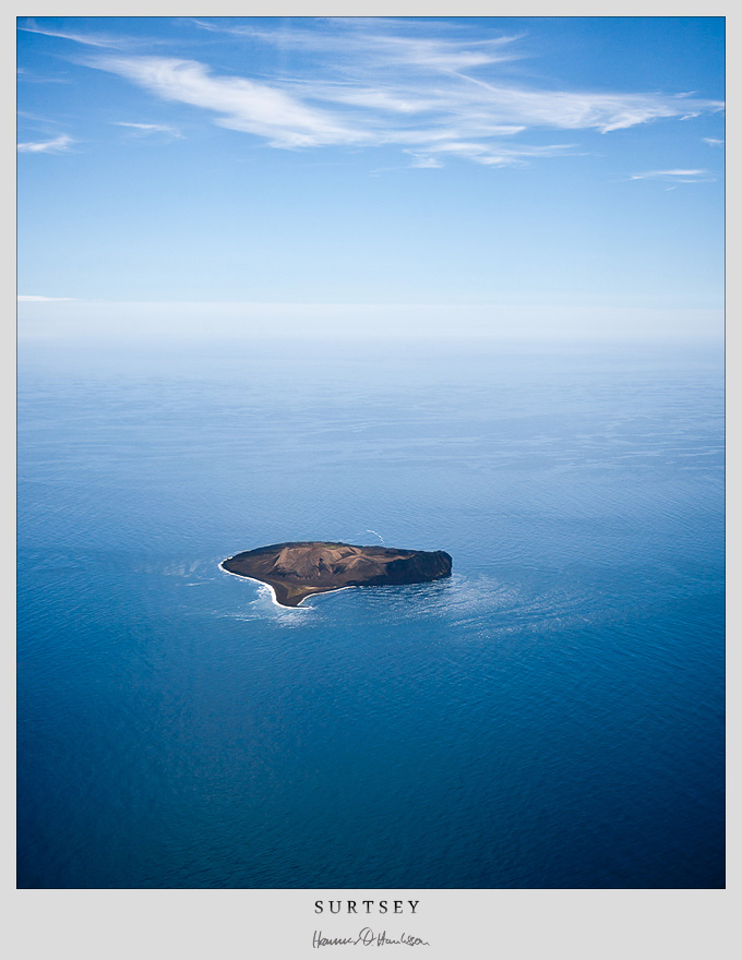
Why is it interesting? Surtsey was created by a submarine eruption that started in 1963. The eruption lasted over three and a half-year and the island was about 2,7 square km when it finished. From the beginning, the island has been protected and off-limits for most people, but scientists visit it to gain insight in how nature evolves on new land. By 2004 the island was already home to 60 vascular plants, 75 bryophytes, 71 lichens, 24 fungi, 89 species of birds (57 of wich breed elsewhere in Iceland) and 335 species of invertebrates. A tomato plant started to take root on the island at one time, but since it was the result of improperly handled human defecation, it was destroyed.
In 2003 the island was thought to be 1,4 square km, having shrunk by almost 50%. In 150 years it might have disappeared almost completely.
The eruption, and the „birth of new land“ was monitored closely by media and is thought to have been quite unique. Surtsey is a UNESCO world heritage site, the only other one in Iceland being Þingvellir National Park.
How to get there? Bar from being a scientist with a very good reason, Surtsey can only be enjoyed from the sea. You can get boat rides from Heimaey.
3. Flatey, Breiðarfjörður
Where is it? In Breiðafjörður bay, between Snæfellsnes peninsula and the Westfjords peninsula, in West-Iceland.
Why is it interesting? Flatey is one of thousands of islands in the Breiðafjörður bay and around 40 or so smaller islands belong to Flatey. At one point the was the most important centre of culture and education for the whole country. This was after a monastery was founded there in 1172. On both sides of the 17th century, Flatey was a thriving international trading post and some important steps in Iceland‘s fishing history were taken by the islanders as well.
Today, 9 people are listed with phone numbers on the island, who has inspired many of Icelandic artists throughout the centuries. Recording artist Lay Low recorded one of her album there, out in a field, and named it Flatey. Soothing background noise from the island‘s nature decorate the soundtrack, as well as an ambitious rooster.
Flatey is thought to have been formed in an eruption roughly 11-12 million years ago. Almost 150 kinds of flowering plants have been found there, and about half of Icelandic nesting birds lay their eggs in the Breiðafjörður bay, so birds are of no shortage in Flatey.
How to get there? Flatey is the half-way-stop for the ferry Baldur, wich goes between Stykkishólmur and Brjánslækur, across the Breiðafjörður Bay, daily during winter and twice a day during summer. You can bring your car on the ferry, but be advised that no cars are allowed in Flatey!
2. Grímsey
Where is it? On the arctic circle, that‘s where!
Why is it interesting? It‘s the Northernmost inhabited place of Iceland. In fact, the only part of Iceland closer to the North Pole is Kolbeinsey, and that‘s disappearing fast. Grímsey is about 5.3 square km in size and the shortest distance to mainland Iceland is 41 km. Due to the Northernly position, the sun doesn‘t quite dip below the horizon in the days surrounding summer solstice.
There is a village on the island, with less than 100 people, relying primarily on fishing for income. No less than 60 species of bird can be spotted on the island during summer, and the occasional polar bear drifts there on an iceberg from Greenland. During the late 1800‘s islanders had a reputation of being good in chess. American Daniel Willard Fiske found out and donated a chess set to every house on the island, as well as a considerable amount of money after his day, asking that a school would be built on the island. Fiske‘s birthday, November 11th, is still celebrated on the island. Fiske himself never actually visited Grímsey, but a lot of tourists do. If you are interested, you can get a certificate stating that you have indeed visited the arctic circle, during your stay. And, you can play chess in a hut tub.
How to get there? Grímsey has a domestic airport, with regular flights. Five days of the week the ferry Sæfari will take you there from Dalvík.
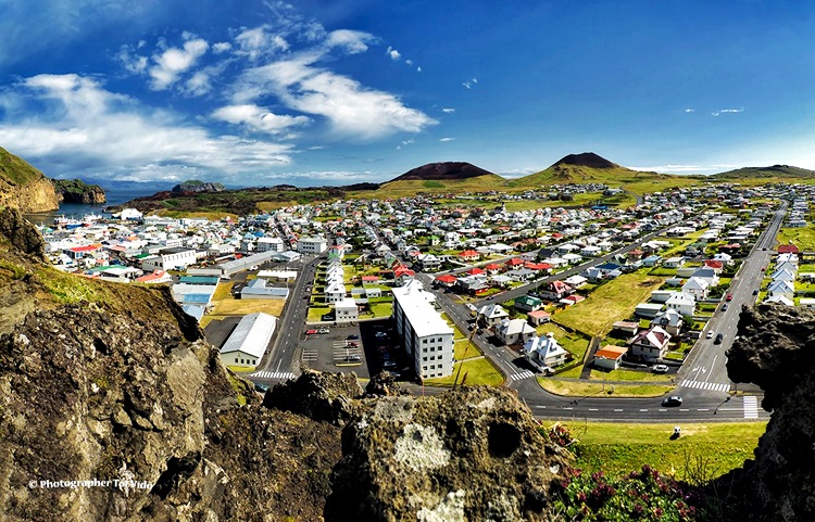
1. Heimaey
Where is it? South of mainland Iceland, less than 10 km from the shore.
Why is it interesting? Heimaey is the largest of all islands around Iceland, and one of about 15 Vestmannaeyjar (Westmen islands), just like Surtsey. The islands get their name from the Irish (Westmen) slaves that were killed there by Icelands‘ first settler, Ingólfur Arnarson. Ingólfur was taking revenge for the slaying of his brother.
Heimaey is thought to be about 5200 years old and cape Stórhöfði (6000 years old) is the Southernmost inhabited part of Iceland. Although it‘s dramatically more populated with puffins then people, or about 700 000 of them. About 4000 people live on the island and rely on fishing and tourism for income.
In 1973 a big eruption woke the islanders up and the island was evacuated completely overnight, apart from a few men who stayed behind to try to rescue houses, the harbour and other important features from the molten lava. The eruption lasted for more than 5 months and ended up destroying almost half of the houses on the island, burying many of them in lava or ash. A museum with excavated houses is a good stop to make on your tour around the island, as well as walking on the new lava and feeling the heat underneath, that is still detectable in some places.
In 1627, about half the islanders were abducted by pirates in an event known as the Turkish abductions (although it‘s unlikely any Turkish people were involved).
There are many things to do on your trip around Heimaey, including visiting a natural museum with emphasis on fish, playing a game of golf, hiking on fairly new land, various boat trips and more.
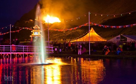
The first weekend of August is a big weekend in the island, as the biggest music festival of the year takes place in dramatic Herjólfsdalur valley, named after Herjólfur Bárðarson – the first man to claim land in Heimaey in the 10th century.
The locals think highly and fondly of their island, and as a testimony of their modest self-image, some of them never refer to mainland Iceland as anything else than „the North-island“.
How to get there? Heimaey has a decent domestic airport with flights to and from Reykjavik and Bakki (closest airport on the mainland). The ferry Herjólfur sails from “Sandeyjahöfn” (shortest route) whenever the harbour there isn‘t full of sand, or from Þorlákshöfn. You can bring a car on the ferry, but you can also stay the night and see most of the island by foot on two or three days.
Þjóðhátíð from Benzophoto.
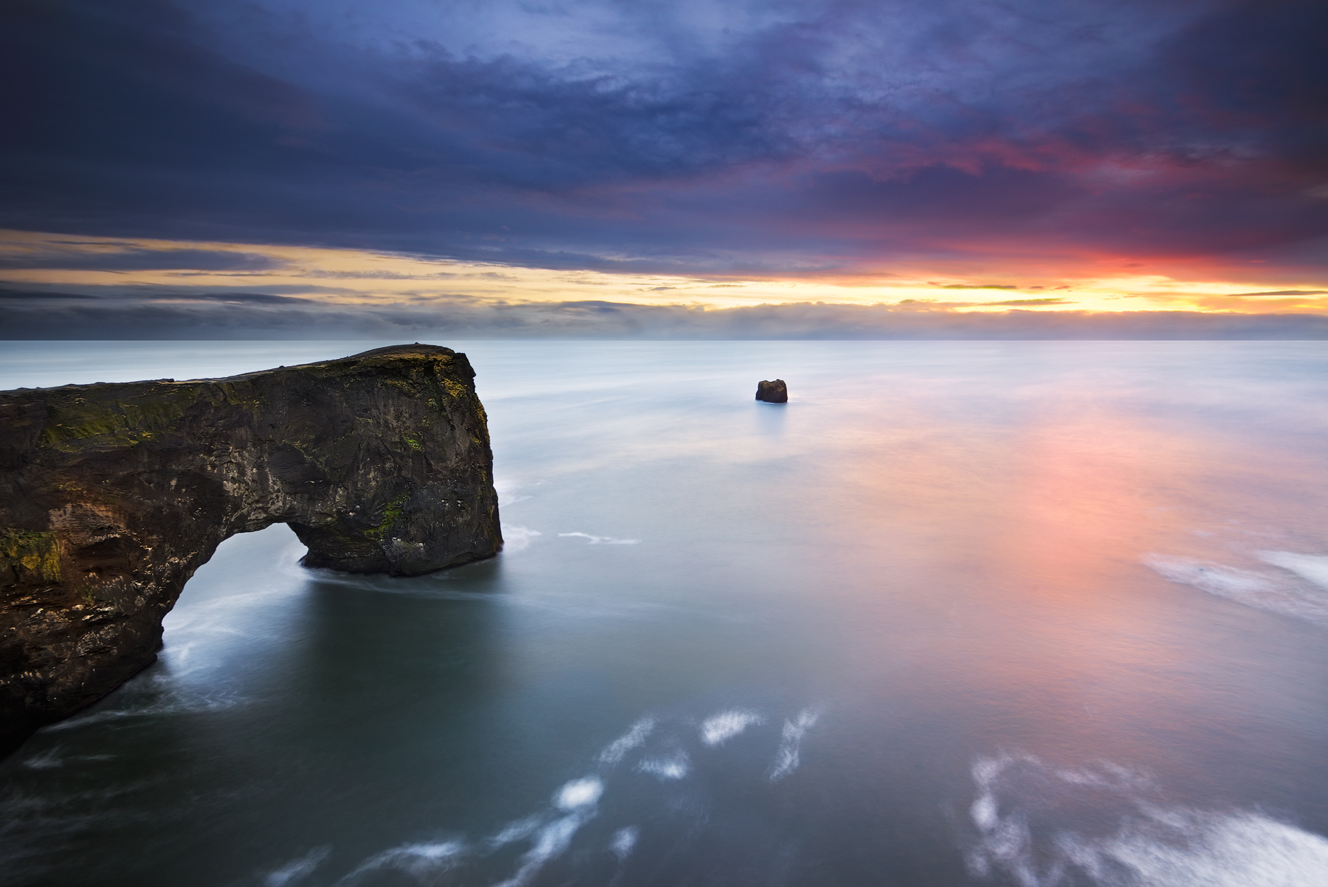
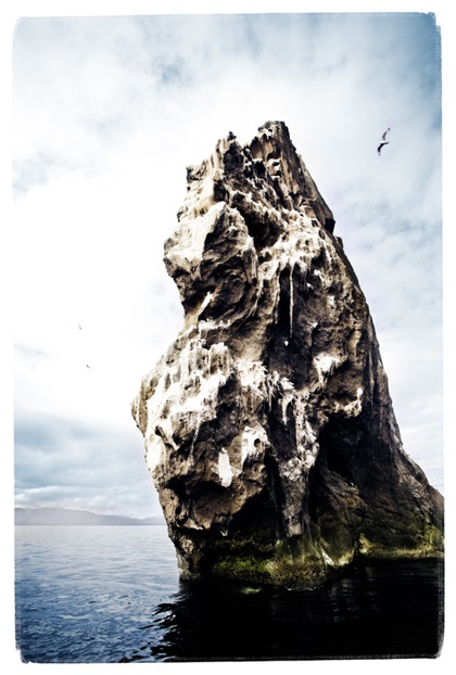
Main photo: Although not a part of this list Lundadrangur, Dyrhólaey is breathtaking. The small peninsula, or promontory is located on the south coast of Iceland, not far from Vík í Mýrdal. Photographer Carlos Rensende.
Note: Should you wish to read more of the text quoted in the beginning, the name of it is Devotions upon emergent occasions and several steps in my sickness – Meditation XVII.